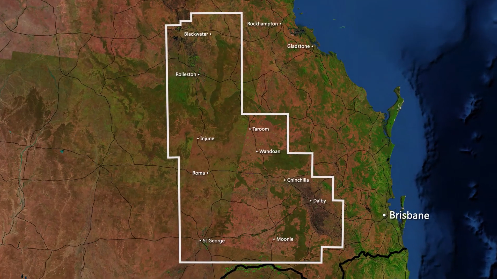
Infrastructure and activities
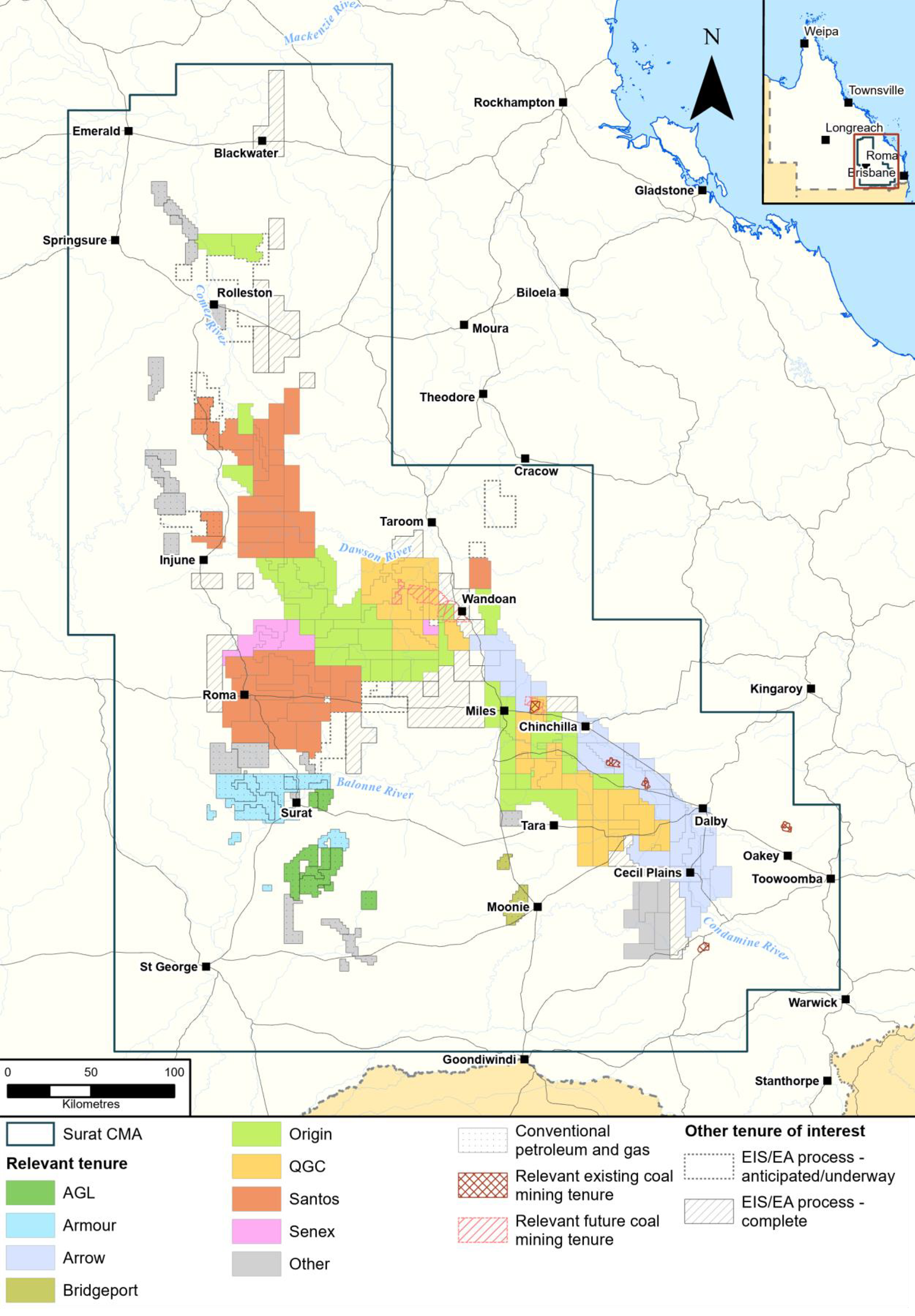
Petroleum and gas industry footprint and tenure
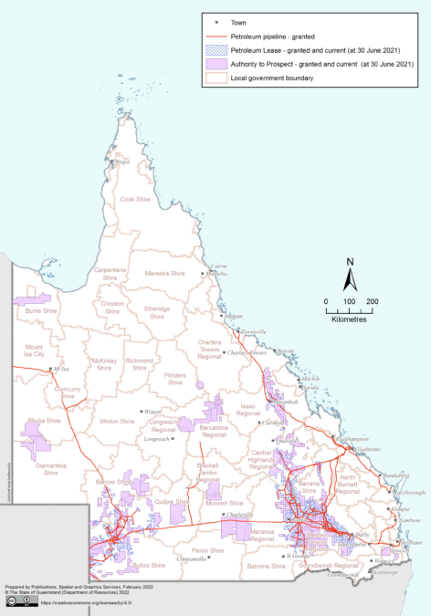
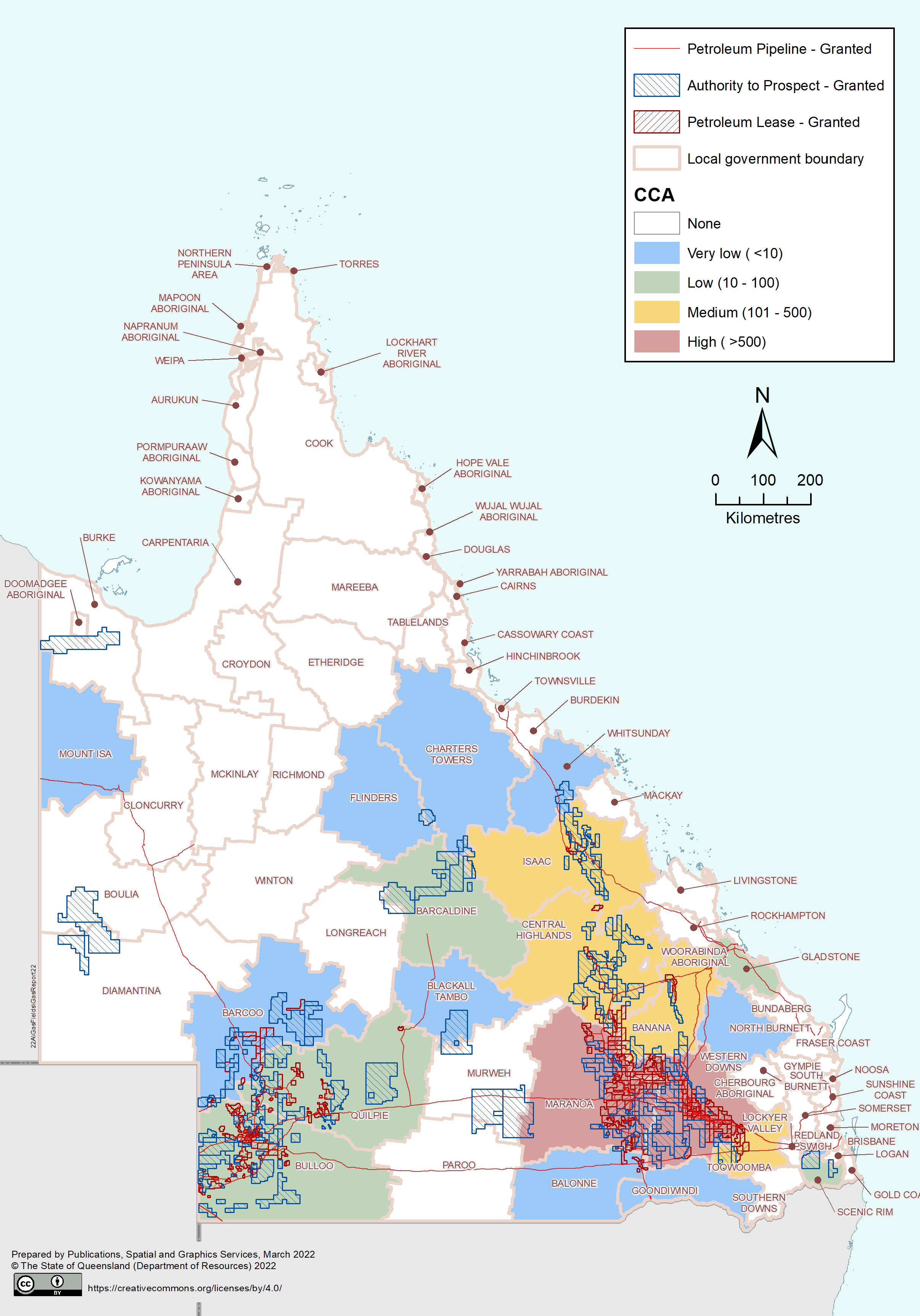
Coverage of land area in Queensland as defined by granted exploration tenures (ATPs), petroleum leases (PLs) and petroleum pipeline licences (PPLs) as of 30 June 2021
The area under tenure does not typically reflect the actual surface footprint of petroleum and gas activity. The actual footprint of gas industry activity and infrastructure is much smaller than the area under PL or ATP tenure due to resource companies concentrating their production in certain areas.
Development profile and planned production scenarios as of 2020
Typically, about 50 to 70% of the total tenure area is used for production purposes with some parts of a tenure never being developed.
The predominance of conventional activity in the west of Queensland compared to CSG activity in the east
At its highest peak (as of June 2021), CSG and petroleum well footprint covers approximately 0.17% of land surface in the Western Downs area (where there is an average of 17 wells per 10,000 ha). The density is even lower in the Maranoa LGA, where there is an average of around five wells per 10,000 ha. The density of development activities differs when comparing conventional and CSG field developments
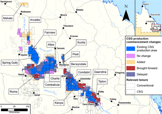
Surat CMA development profile and planned production scenarios as of 2021
The maturing of conventional petroleum and gas activity in the Cooper Basin means that the number of wells being drilled are declining, compared to CSG and other unconventional resources that are still developing, particularly in the Surat and Bowen Basins.


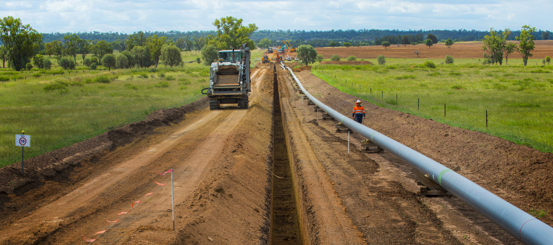
Pipelines
For safety reasons all pipelines (large-diameter, high-pressure transmission pipelines and gathering lines that transport gas over long distances) are positioned underground. Only under certain circumstances will sections of pipeline be positioned above ground (such as for ongoing maintenance purposes).

Well pads
Well pads are typically comprised of well heads, separator, and compressors (this varies amongst resource companies).Well pads are easily visible due to their positioning on a well cleared area, typically measuring 100 m x 100 m in size1 during drilling operations. For the purpose of this report, the well footprint refers to the area of the well pad.
The terms ‘conventional’ and ‘unconventional’ refer to the techniques and technologies required to extract the gas from host rocks. Conventional resources are extracted using traditional methods, drilling wells directly into a subsurface reservoir where oil and gas is trapped in a geological structure. Unconventional resources are those that require greater than industry standard levels of technology or investment to extract. Find out more on the CSIRO website: What is unconventional gas?
Queensland has approximately 12,437 km of petroleum pipeline licences (PPLs) that have been constructed and are in operation, with another 57.9 km in the application stage.
Approximately 920,500 ha of petroleum and gas tenures granted have a condition attached whereby the gas produced must be supplied to the Australian domestic gas market. This condition was introduced in 2016 to secure gas supply to the east coast gas market and for the manufacturing industry.
In the Surat Basin and Cooper Basin, the majority of significant infrastructure has already been constructed and commissioned. It can be expected that the scale of construction activity experienced in the Surat Basin between 2010 and 2015 will not be repeated as development expands into new areas. The Maranoa and Western Downs LGAs, situated in the Surat Basin, host the majority of Queensland’s CSG activities. As new and emerging areas develop further, increased activity can be expected in the Banana, Central Highlands and Isaac LGAs.
Despite an increase in the planned production areas over the longer term, there has been an overall slowing in the rate of development in the short term – likely a response to the market conditions related to the COVID-19 pandemic.
Petroleum and gas wells
As of 30 June 2021, a total of 16,499 CSG and petroleum wells had been drilled in Queensland (across all tenure types) since records began in 1901. Of these wells:
- 12,941 targeted CSG with 96% located within the Bowen and Surat basins, and the remainder (529 wells) located in other basins
- 3,558 targeted conventional and other unconventional resources (non-CSG), 48% of these are located in the Cooper-Eromanga basins, 44% in Bowen-Surat basins, and 8% located in other basins.
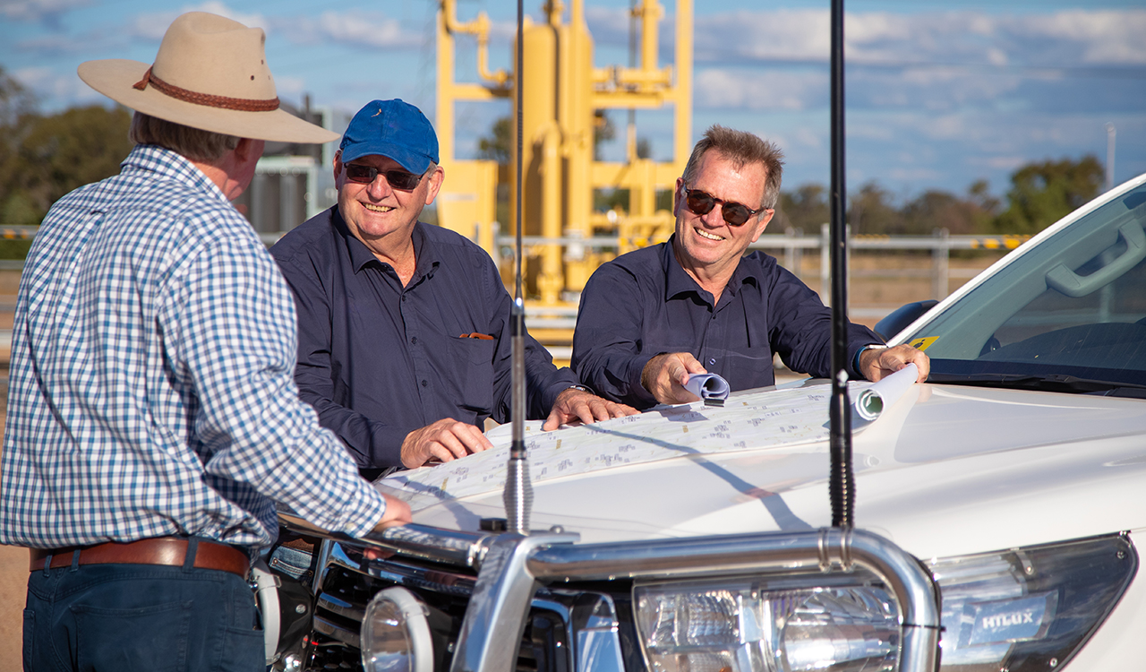
Petroleum tenures are often on properties not owned by the tenure holder, and agricultural businesses are typically either leasehold or freehold property. As such, petroleum and gas tenures often overlap with other land uses. Before a resource company can access freehold or leasehold land, it must obtain the necessary approvals from government and comply with land access requirements.
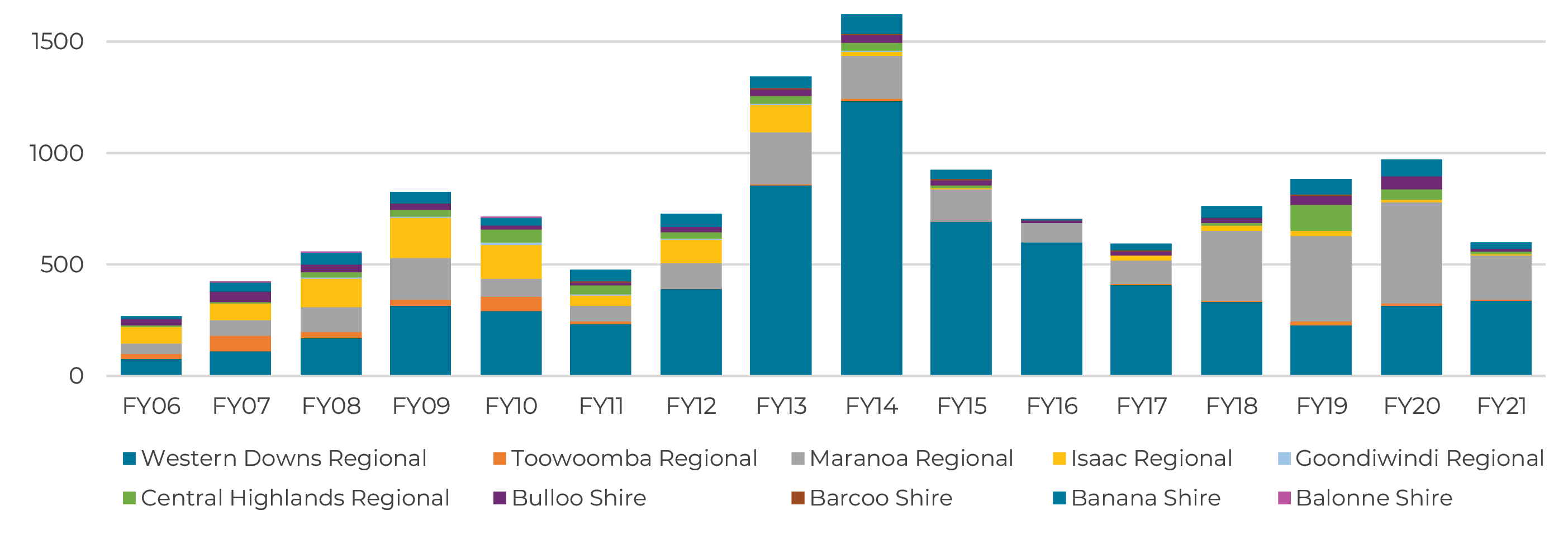
Total petroleum and coal seam gas wells drilled in each local government area (LGA) for financial years 2006-2021
Growth in producing CSG and petroleum wells
The growth in the number of producing petroleum and gas wells since FY14

As of 30 June 2021, there was a total of 9,461 producing petroleum and CSG wells in Queensland. The number of CSG wells in Queensland has grown rapidly since 2010 to support Queensland’s growing LNG export industry.
It is important to note that at any point in time, not all petroleum and or CSG wells that have been drilled are in production. Some wells have been decommissioned (plugged and abandoned), some have been repurposed (converted into water bores, reinjection wells, or monitoring bores) while others are capped/shut-in/suspended. Therefore, the total number of producing wells is far fewer than the total number of wells drilled.
INSIGHTS
As technology has improved over the years, many changes have occurred, particularly in the time it takes to drill wells and with resource companies adapting and introducing new practices to minimise the impacts and surface disturbance for landholders. These include the use of multi-well pads that allow multiple wells to be drilled on a pad, colocation and grouping of infrastructure, negotiating with landholders to locate infrastructure in areas that will least affect their existing farming practices, and increasing use of constraints mapping which restricts development in environmentally sensitive areas.
Agriculture and industry overlap – land use
Queensland has the largest area of agricultural land of any Australian state or territory and the highest proportion of land area in Australia dedicated to agriculture (83%). As the majority of land in Queensland is used for agricultural purposes, it can be expected that resource tenure overlaps with land used for agricultural purposes.
Petroleum and gas resources in Queensland are owned by the State and managed by the Queensland Government on behalf of the people of Queensland. The Queensland Government grants tenures that gives resource companies the right to explore for, produce and transport petroleum and gas.
Primary land use coverage by petroleum production tenures as of 30 June 2021
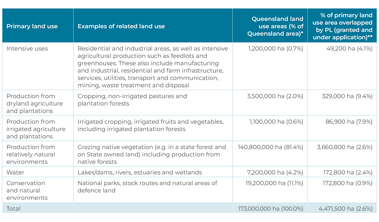
*Qld land use areas in ha are rounded.
**PL Granted and under application. This doesn’t reflect the actual surface footprint of petroleum and gas infrastructure over these land use types (refer to Industry Footprint section).
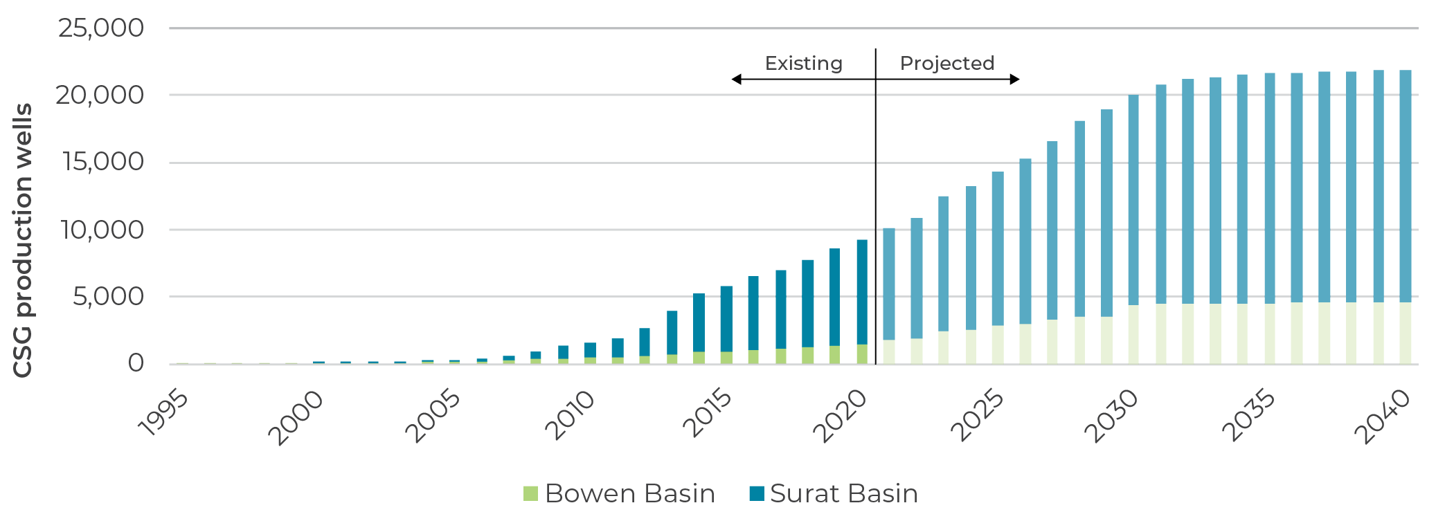
Future well projections within the Surat CMA
By the end of 2021, approximately 8,900 CSG wells were already drilled within the Surat CMA, 84% of which are located in the Surat Basin, with the remainder found in the southern Bowen Basin. There are approximately 500 wells located outside of CSG production areas that are used for exploration or testing purposes.
With the increase in the net production area footprint in the Surat CMA, the total number of projected wells has also increased slightly, from approximately 21,000 wells reported in May 2019, to approximately 22,000 wells by 2050.
Existing and projected CSG wells to 2050
Hydraulic fracturing
The process of hydraulic fracturing (‘fracking’ or ‘fraccing’) is used to stimulate gas production from geological formations with a low permeability.
Only a small percentage of wells are hydraulically fractured. The graphs below show the number of CSG and petroleum wells that were hydraulically fractured compared to those that were not. Only LGAs where wells were hydraulically fractured are included in the graphs.
An overview of the coal seam gas extraction process, from drilling the well to what happens to the extracted gas and water
CSG wells

Petroleum wells

Land access and compensation
Under Queensland’s land access laws, resource companies have the right to access and undertake petroleum and gas activities on a landholder’s property provided that all legal requirements under the land access laws are complied with.
A Conduct and Compensation Agreement (CCA) is required for any advanced activities. Advanced activities are activities that will occur over the longer term and/or have extensive impacts on landholders. This is a legally binding document that specifies the company’s activities and behaviours, respective obligations, and protections. A CCA also ensures the landholder is compensated for the effects and impacts of the advanced activities.
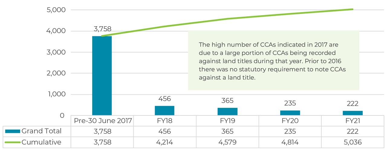
As of June 2021, there were 5,036 CCAs recorded on Queensland land titles. The majority of these are associated with production lease and pipeline licence activities.
Total CCAs registered by FY
Total CCAs registered by LGA

Landholders living in the Maranoa and Western Downs LGAs accounted for 72% of all CCAs

INSIGHTS
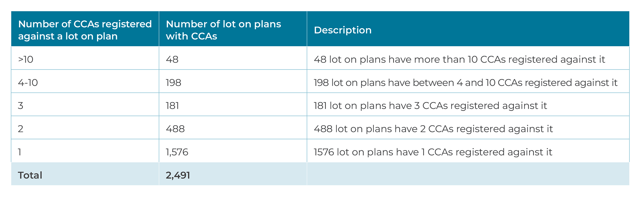
A CCA that is registered on title is also referred to as a “dealing”. A lot on plan may have more than one dealing (CCA) and a dealing may have more than one owner registered on title. The registered owners (or landholders) on title are not limited to individuals, but may include other entities such as corporations, gas companies, regional councils, and the State of Queensland.
Number of lot on plans with the corresponding number of registered CCAs
Compensation paid
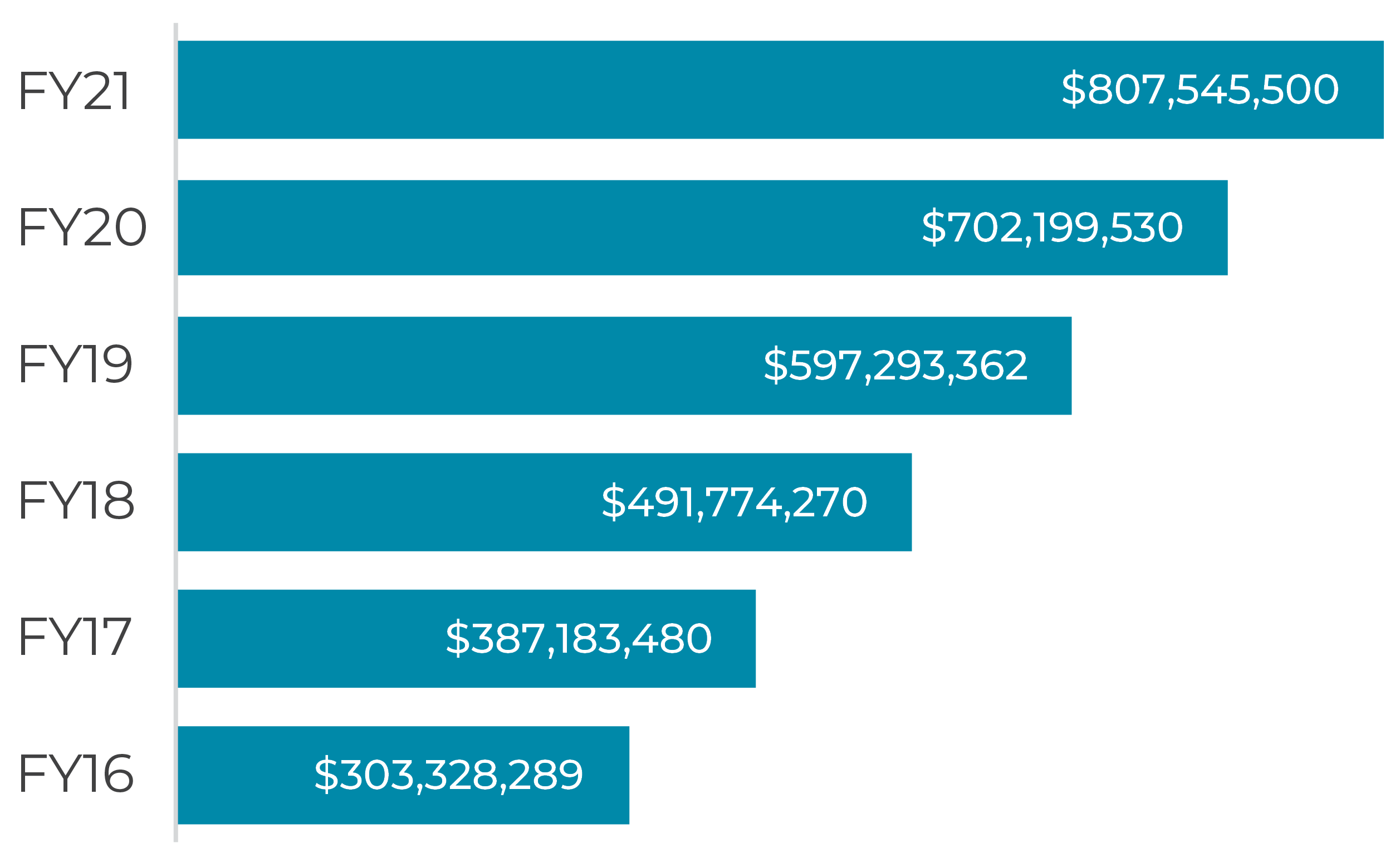
In FY21, $105 million in compensation was paid to landholders for petroleum and gas development activities on their properties.
The cumulative compensation that has been paid to date is more than $807 million.
It is not possible to calculate an individual CCA value as each CCA is uniquely negotiated based on factors such as:
- every property, land value, business operation and profitability is different;
- the type and extent of petroleum and gas activity on each property and impact to a landholder’s operations is different.
Cumulative compensation paid to landholders
Groundwater take and impact management
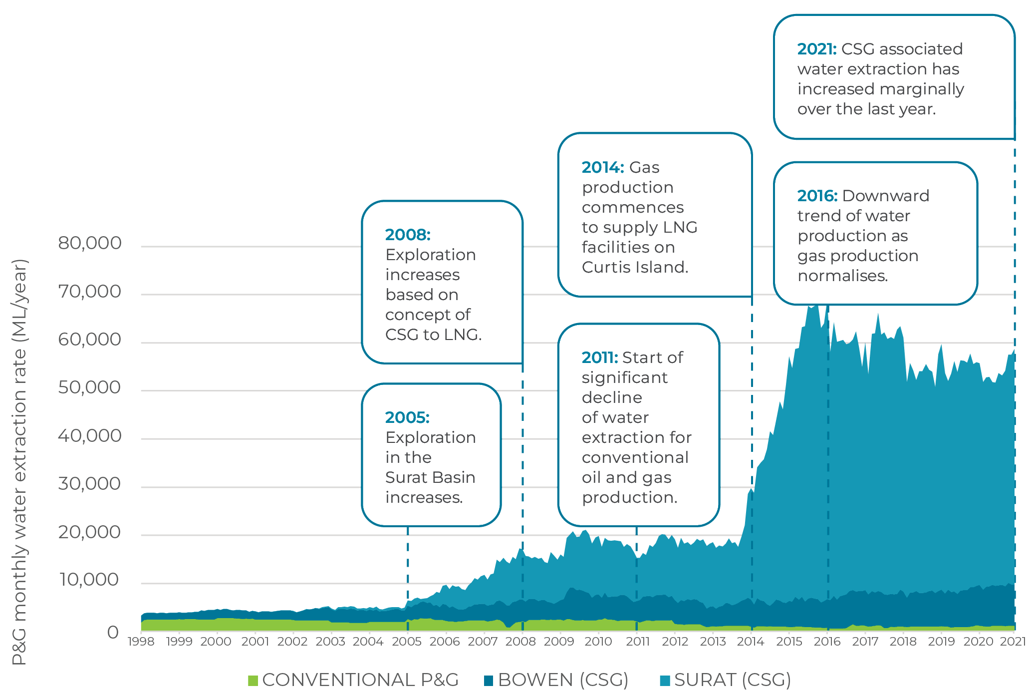
Surat Cumulative Management Area
The estimated total groundwater take from all aquifers across the petroleum and gas producing areas of Queensland for all purposes is approximately 390,000 ML/year.
Most of this is used for agricultural (includes stock intensive and irrigation use) and stock and domestic purposes.
Approximately 66,000 ML/year or 17% of the total water take is for petroleum and gas purposes. Groundwater extracted as part of petroleum and gas operations is known as ‘associated water’
Associated water can be treated and re-used for a variety of applications including farm irrigation, town water supply, reinjection into aquifers and various industrial applications. Associated water extraction from CSG depressurisation and conventional oil and gas production is metered.
INSIGHTS
Resource companies operating outside the Surat CMA are required to submit a Underground Water Impact Report every three years, which includes an assessment of the water level decline in aquifers and any impacts to springs in both the long and short term. Within the Surat CMA, this responsibility rests with the Office of Groundwater Impact Assessment.
The report identifies bores accessing water from an aquifer that are predicted to experience an impact or drawdown of more than the trigger threshold.
Find out more about the Surat Cumulative Management Area
Groundwater take for petroleum and gas activities
The 2021 Surat CMA UWIR reported that average predicted associated water extraction has increased marginally to 54,000 ML/year due to changes in the development profile since the 2019 Surat CMA UWIR. Overall, since 2016, the extraction rate within the Surat CMA has been progressively declining from a peak of around 67,000 ML/year – partially due to reduction in extracted water over time from existing wells and infilling of new wells in areas where partial depressurisation has already occurred.
Historical associated water extraction by the P&G tenure holders in the Surat CMA
Groundwater impact
Under the regulatory framework, resource companies are required to manage the impacts of groundwater extraction undertaken as part of petroleum and gas activities. For example, resource companies are required to take a number of steps to ensure that water bore owners are not disadvantaged by their operations. This includes monitoring and identifying any potential impacts on water bores, to then negotiate the appropriate make good measure in a Make Good Agreement (MGA) for the affected water bore.
Predicted impacts to water bores in the Surat CMA
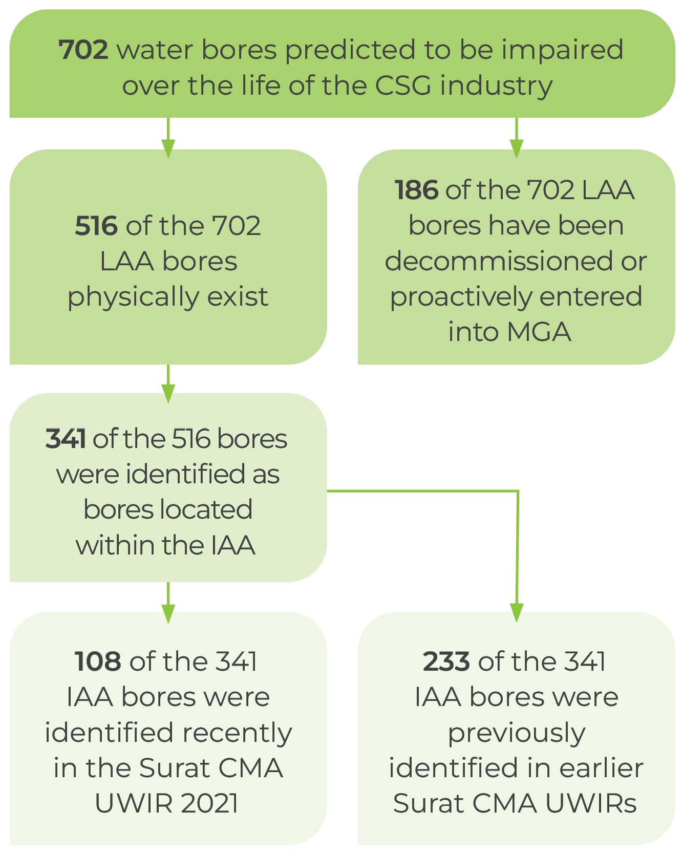
Of the 516 long term affected area (LAA) bores, a total of 341 bores have been identified as also being located within an immediately affected area (IAA). 233 of these bores were identified in the previous UWIR, while 108 of the 341 were identified in the Surat CMA UWIR 2021.
The 108 IAA bores will require follow-up bore assessments by the resource tenure holders (assigned by OGIA for each of these bores based on rules established in the UWIR) to assess impairment of capacity. If a water bore’s water supply is likely to be impaired, then the tenure holder will negotiate and implement an appropriate make good measure with the water bore owner.
MGAs have been successfully negotiated for 135 of the IAA bores. In some instances, MGAs were reached without bore assessments.
Make good measures may include one or more elements based on specific circumstances relating to the affected water bore. Types of make good measures include ongoing monitoring, additional local-scale assessment, rework/modification of existing water bore infrastructure, drilling of a replacement water bore in a non-affected formation, provision of an alternate water supply and financial compensation.
Make Good status of the 233 net IAA bores


Beneficial use
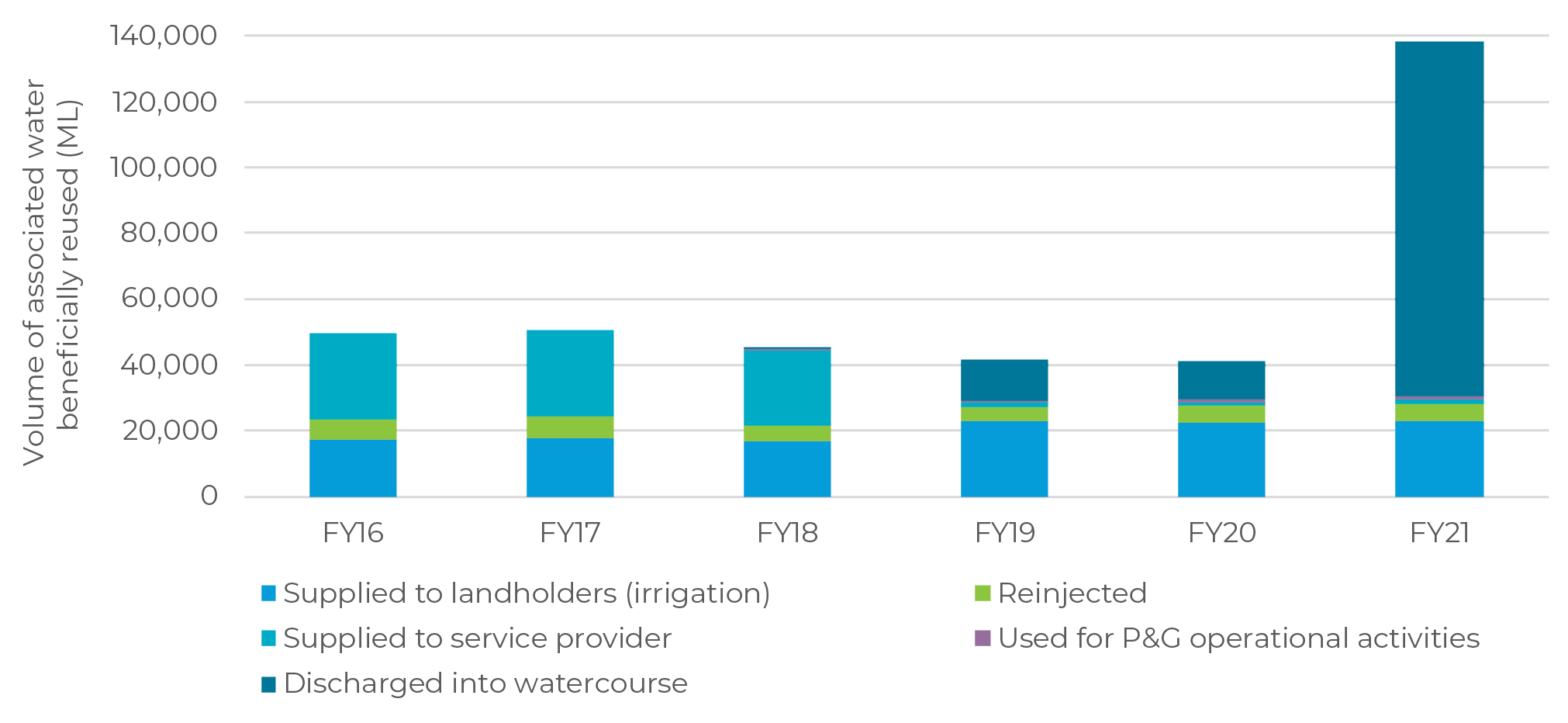
An estimated total of more than 365,000 ML of treated associated water has been beneficially used between July 2015 and June 2021. The graph below shows the distribution of use of associated water over the last six financial years, with the dominant beneficial use being irrigation.
A small portion of associated water is used for purposes of reinjection or petroleum and gas operational activities. In FY21 the majority of associated water was treated and discharged into water courses.
Volume of associated water used beneficially for various purposes from FY16 to FY21
Find out more
For additional information, insights and data, please download a PDF.
📄
Download topic PDF
Infrastructure and activities
📑
Download full report PDF
Shared Landscapes – Industry Trends